

PeakVisor - 3D Maps & Peaks ID
Discover the Peaks with PeakVisor
Discover the Peaks with PeakVisor
Imagine you're standing on a mountain top, looking out at an amazing view, and you start wondering what all those stunning peaks are called. Good news—you don't have to wonder anymore! With the PeakVisor - 3D Maps & Peaks ID app, figuring out the names of mountains is super simple and adds a fun twist to your trips. This app makes every hike more interesting, turning your outdoor adventures into a chance to learn something new.
Features That Make Your Hikes Better
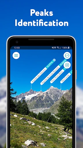
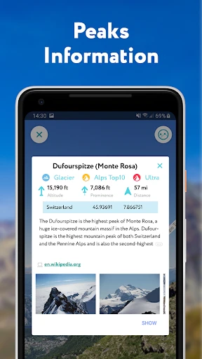
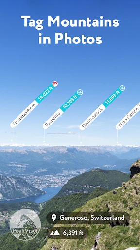
PeakVisor comes with lots of useful tools that are great for both new hikers and experienced climbers. Its main job is to recognize mountain peaks using your phone's camera, and it does this really well. Just aim your phone at the horizon, and you'll see the names and heights of the peaks pop up on your screen. It’s like having a personal mountain expert right in your pocket!
Another cool thing about PeakVisor is its 3D maps. These aren't ordinary flat maps—they're interactive, detailed, and help you understand the lay of the land much better. You can zoom, spin, and tilt the map to see the hiking area from different angles. This is super helpful when you're planning your path and want to know what the ground is like.
Easy Navigation and Using It Offline
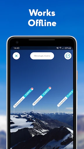
Worried about not having a phone signal out in the wild? PeakVisor takes care of that. You can download maps to use when you're offline, so you won't get lost even in places with no service. This is perfect for anyone who loves exploring remote spots.
On top of that, the app’s navigation tools are excellent. It shows you clear hiking routes and follows where you are in real time. You can save the trails you like and send them to friends, making it simple to plan group adventures.
What Makes PeakVisor Special
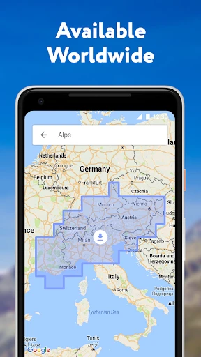
What really makes PeakVisor stand out is how easy it is to use. The layout is clean and simple, so even if you're not great with technology, you won't have any trouble finding what you need. The app also includes a huge collection of over a million peaks around the world, and it's always being updated so the info is correct.
Plus, PeakVisor works with virtual reality (VR), which is a fun way to check out trails and mountain views before you even leave home. This adds a new layer to trip planning, helping you picture the paths and peaks you're going to see.
Your Go-To Guide for the Mountains
To sum it up, PeakVisor - 3D Maps & Peaks ID isn't just another hiking app—it's your best friend for mountain trips. No matter if you hike once in a while or climb all the time, this app makes your journey better by giving you helpful info and tools whenever you need them.
So next time you're getting ready for a hike, make sure you have PeakVisor downloaded. You'll not only find your way like an expert but also learn more about the beautiful nature around you. Have a great hike
- Developer
- Routes Software SRL
- Version
- 2.8.71
- Installs
- 10,000+
- Android Version
- 8.0
- Content Rating
- Everyone
- Price
- $4.99
- Highly detailed 3D topographic maps.
- Offline maps available for remote areas.
- Accurate peak identification feature.
- User-friendly interface with easy navigation.
- Regular updates with new trails and peaks.
- Requires subscription for full features.
- Battery consumption is relatively high.
- Limited features on offline mode.
- Occasional lag in peak identification.
- Not suitable for non-mountainous regions.